

Compiled by MALIK MERCHANT
Publisher/Editor Simerg, Simergphotos and Barakah
The David Rumsey Historical Map Collection focuses on 16th through 21st century maps of North and and South America, as well as maps of the World, Asia, Africa, Europe, and Oceania. Atlases, globes, school geographies, maritime charts, and a variety of separate maps including pocket, wall, children’s and manuscript maps are present on the website. The depth and breath of the digital collection is impressive, and is continuously growing. The website notes that the actual physical map collection is housed at the David Rumsey Map Center at the Stanford University Library.
My search on the website using the term “Fatimid” yielded one result. It is a map produced in 1924 by the Survey of Egypt, which was once regarded as “one of the most professional mapping agencies in the World, predicated upon the synergy of the most authoritative topographical and urban mapping combined with the latest archaeological surveys.”
Simerg is pleased to reproduce the map, along with an interesting narrative that accompanies the map on the David Rumsey Map Center website. We also invite readers to click on the link to enrich their viewing experience of the map, download the map (by using the Export Function) as well as to explore other maps that may be of interest to readers or to provide them with further information in their specific area of research.
Cairo During the Islamic Golden Age
Please click on image for enlargement
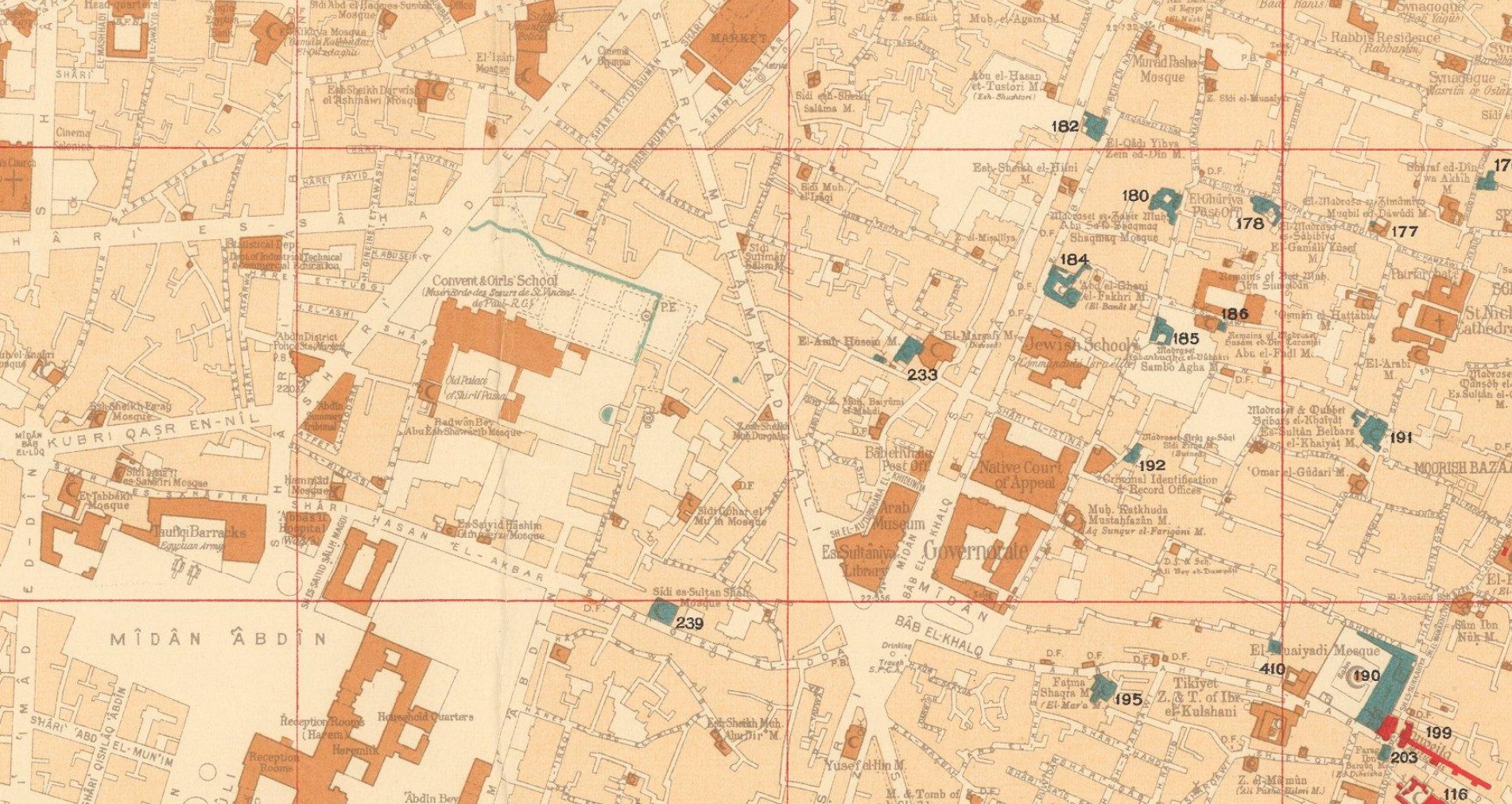
Cairo was the greatest centre of culture, learning and commerce during the ‘Islamic Golden age’. Commencing in the early 20th Century professional archaeologists as well as art and architectural historians became interested in scientifically recording Cairo’s sensational Islamic buildings and monuments.
The map employs colours to denote sites built across the city during the eras of the three great Islamic empires that controlled Cairo prior to the arrival of the Ottomans in 1517: the ‘Fatimid and Pre-Fatimid Monuments’ (909 – 1171), shaded in Red; the ‘Aiyubid [Ayyubid] Monuments’ (1171 – 1260), shaded in Green; and the ‘Mameluke Monuments’ (1260 – 1517), shaded in Blue.
These mosques, palaces, madrassas, and fortifications appear amidst the otherwise buff-coloured city which generally consisted of buildings built during the subsequent Ottoman and British Protectorate periods.
The map shows that many of the greatest edifices from the periods of the three great Islamic empires have survived, although only traces of the vast Fatimid Place can be found amongst the foundations of newer buildings. Each of the historical sites is named in Gothic script and features a corresponding numeral which refers to that which appears upon the plaques affixed to each building by the civic authorities. The two insets on the left-hand side showcase sites in areas outside of the city proper. We understand that the first edition the map was issued in 1924, while an Arabic language version was published in 1948. The present revised, official edition was issued in 1950-1 (correction, this copy is the first edition, issued in 1924), while several facsimile (unofficial) versions have been issued since then. The Survey of Egypt followed the initial production of the present issue of the map with a small booklet, Index to Mohammedan monuments appearing on the special 1:5000 scale maps of Cairo (Cairo, 1951), that is not present here, but seems to have been issued with the latter-releases of the map.
Cairo during the ‘Islamic Golden Age’ Cairo was traditionally the largest and most culturally and economically important city in the Islamic world. The Muslim conquest of Byzantine Egypt occurred between 639 and 646 AD. While the Cairo area has been settled for thousands of years, with the key Ancient Egyptian cities of Giza and Memphis located nearby, the city proper was not founded until 969, when it became the principal city, and sometimes capital, of the Fatimid Caliphate, a Shia Muslim empire which controlled much of North Africa, the Levant and Hejaz between 909 and 1171.
Cairo rapidly rose to become a centre of great wealth, at the nexus of global trade routes as well as home to some of the world’s foremost centres of education and the arts. Befitting its importance, great monuments of Islamic architecture were built across the city.
The Al-Azhar Madrassa (no. 97 on the map), which later grew into a university, was founded in 970-2 and today remains the world’s most prestigious institute of Islamic learning. The map notes some Islamic monuments made before 969, as the pre-Cairo rural landscape featured some small mosques, houses and fortifications.
The Fatimids were replaced by the Ayyubid Dynasty (1171 – 1260), a regime of Kurdish origin, founded by the legendary conqueror Saladin, whereupon Cairo remained the prosperous centre of an empire spanning much of the Middle East.
The Mamelukes were an elite class of soldier-bureaucrats descended from former Christian slaves. In 1250, they took over Egypt, the Levant and Hejaz, forming the Mameluke Sultanate, with its capital in Cairo. It was during the early part of their regime that Cairo reached its zenith as the principal centre of the Islamic Golden Age.
The epicentre of a global trading network that spanned from India to Spain, Cairo far surpassed all European cities in wealth and cultural sophistication, and many exquisite works of architecture were built to reflect this glorious state. The Mameluke Sultanate was conquered by the Ottomans in 1517 and Cairo ceased to be an imperial capital. However, while technically subject to the Sublime Porte, Egypt maintained a high degree of autonomy and was the wealthiest and most prosperous part of the Ottoman Empire; Cairo remained a highly important centre.
Fortunately, as the repent map reveals, the survival rate of Cairo’s great works of Islamic architecture from the Fatimid, Ayyubid and Mameluke periods is impressively high, and many sites can be visited today. References: OCLC: 17543226. (Alexander Johnson, 2020).
Date posted: February 22, 2022.
________________________
Before leaving this website please take a moment to visit Simerg’s Table of Contents for links to hundreds of thought provoking pieces on a vast array of subjects including faith and culture, history and philosophy, and arts and letters to name a few. Also, visit Simerg’s sister websites Barakah, dedicated to His Highness the Aga Khan, and Simergphotos that features photos and videos from around the world.
Malik, the founding publisher and editor of the 3 websites, may be reached at his email address, mmerchant@barakah.com.
